High Resolution RPAS Survey Forms Part of a River Digital Twin®
The Background
- Date
- Winter 2025
- Client
- Stantec
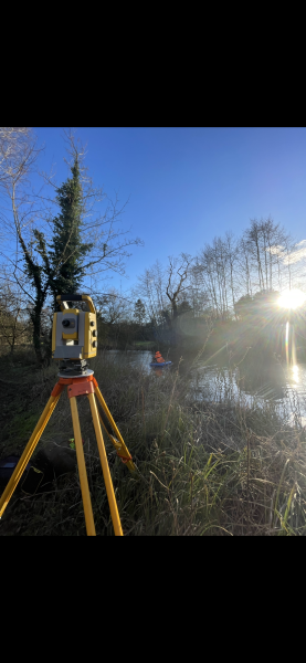
The survey covered a 7 km stretch of Waskerley Beck, from the reservoir’s discharge point to Tunstall Reservoir. To achieve this, a high-resolution LiDAR RPAS survey was conducted to capture crest levels, spill points, and flood-prone areas, ensuring a cost-effective and comprehensive dataset.
Additionally, two key hydraulic structures were surveyed with a higher level of accuracy. Given the remote nature of the site, a combination of drone-based and ground control methods was used to ensure data reliability.
The Challenge
This survey project presented multiple technical and environmental challenges:
- Harsh Terrain: Situated in the North Pennines, the area featured steep hills and rough ground leading down to the beck. These conditions required careful planning to ensure complete data coverage while maintaining safety and efficiency.
- GNSS Signal Limitations: The remote location and undulating landscape made real-time Virtual Reference Station (VRS) corrections unreliable. To mitigate this, Post-Processed Kinematic (PPK) GNSS techniques were applied to enhance positional accuracy.
- RPAS Flight Constraints: Maintaining Visual Line of Sight (VLOS) within 500m proved difficult due to the terrain. Surveyors had to continually reposition and adjust flight plans accordingly to comply with regulatory requirements.
- Unpredictable and Harsh Weather: The survey was conducted in challenging conditions, with high winds and heavy rain affecting flight operations. Adjustments to the schedule were necessary to ensure data quality and flight safety.
The Process
Despite the challenges, the survey was successfully completed using advanced methodologies:
- RPAS LiDAR Survey: A high-resolution LiDAR drone survey captured topographical data, providing detailed information on crest levels, spill points, and flood-prone areas.
- Ground Control and PPK Processing: GNSS ground control points were strategically placed to enhance the accuracy of the LiDAR data, with PPK corrections applied where necessary.
- Detailed Structure Surveys: Two hydraulic structures were surveyed with increased precision, ensuring accurate measurements for hydrological analysis.
The Result
The survey successfully met the requirements set out by our client. Key deliverables included:
- High-accuracy structural data – Providing refined measurements for the two surveyed hydraulic structures.
- Classified LiDAR Data – The LiDAR dataset was classified into ground and non-ground layers, ensuring accurate terrain representation.
- Elevation GeoTIFF – The ground-classified LiDAR layer was used to generate a high-resolution elevation model.
- 2D Ortho imagery – Captured separately, the orthoimage achieved a 1cm Ground Sample Distance (GSD), offering precise visual references.
Despite the complexities posed by the terrain, weather, and technical constraints, the River Digital Twin ® of Waskerly Beck was successfully completed to a high standard. The data collected will inform a precise discharge impact analysis, aiding in improved water management strategies for the region. This project highlights the effectiveness of RPAS and hybrid survey techniques in challenging environments, ensuring that critical hydrological data is captured with accuracy and efficiency.
Recent News
From Dee to Data: Storm Delivers Dynamic River Data
What’s Driving Our Success in Surveys & Leadership?