Geospatial Mapping of Islington Canal Tunnel – How do we do that?
The Background
- Date
- July 2024
- Client
- GeoTerra / Canal Rivers Trust
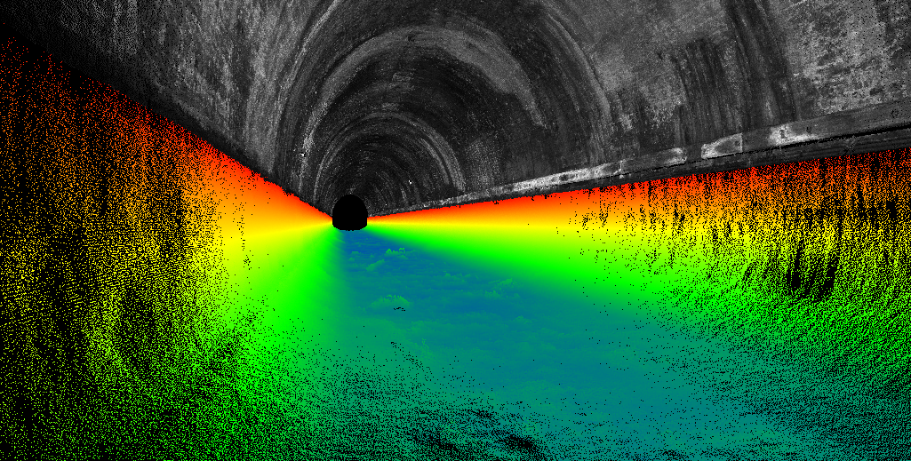
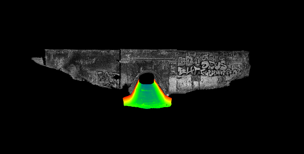
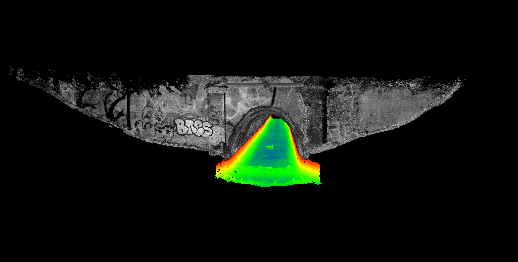
The Islington Tunnel is an asset owned by the Canal & River Trust (CRT) that spans approximately 880 meters of the Regent’s Canal in Islington, London. Constructed in 1818, the tunnel features a brick-lined structure with east and west portals made of brick and stone dressing. It measures roughly 5.2 meters wide at the water level, with a depth of 2.2 meters and a clearance of 5.5 meters. Initially, barges were legged through the tunnel, but in 1826, it was upgraded with a steam engine tug pulling a guiding chain. Diesel engines replaced the steam engines in the 1930s, before self-propelled barges took over shortly afterward.
The Challenge
Storm’s industry partner Geoterra were approached by CRT to create a complete georeferenced 3D model of the tunnel. This model would serve as a baseline for monitoring cracks, defects, and structural movement. Undertaking an initial review of the project, several challenges quickly emerged:
- 900 meters without GNSS coverage
- Seamless integration of above and below water survey data
- Working in central London with limited parking and only pedestrian access
- Limited access due to the lack of a towpath within the tunnel
- The canal tunnel is in constant use
- Environmental concerns due to bats residing in the tunnel
- Grade II listing of the portals and tunnel structures
- Interest from the Great British Public
Mark Hudson of Geoterra engaged Storm Geomatics to lead the tunnel survey, leveraging our expertise in bathymetric surveys in hard-to-reach areas, we eagerly accepted the challenge and began devising a comprehensive survey plan. The most challenging aspect was controlling both above and below water surveys without GNSS signals. Storm partnered with Korec to utilise their MX50 mobile mapping system, which features a state-of-the-art Applanix INS/GNSS system.
The Results
To fully understand the task ahead, a site walk was conducted. CRT provided a work barge, allowing the team to view the entire tunnel and surrounding area. Control installation dates were set, with CRT arranging for tunnel closure from 7 PM to 7 AM.
A team of three surveyors mobilised to the site with a lightweight survey vessel supported by a CRT workboat. On the first night, the team installed 19 threaded steel sockets, secured using CRT-approved epoxy resin, with lime mortar on hand for any necessary brickwork repairs. Control points were installed near each portal using a Total Station (TS) on a frame placed 2 meters inside the east and west portals.
On the second night, a prism was mounted into each socket. Observations from the TS 2 meters inside the portal entrance coordinated each target. Two targets were surveyed from each portal end, with the largest discrepancy being 13mm. Once all targets were coordinated, they were removed, and a cap was placed on each socket.
A week later, the team returned with a Norbit iWBMS and MX50 Mobile Mapping system, which were mounted on custom-built frames and fitted to the workboat. The entire boat was scanned using the SX10 for accurate positioning of sensors. After calibration, the vessel made several passes through the tunnel, adjusting the multibeam sensor head each time to achieve the best resolution.
The above-water survey was processed using terrestrial scans of the portals and the coordinated targets. The resulting data provided the finished point cloud for the above-water area and corrected SBET (trajectory) files necessary for processing the bathymetric data. With the final corrected SBET files, the Storm team processed all runs and produced a combined point cloud of the below-water area. The portal scans, along with above and below water data, were then combined and delivered to the client.
While the project was challenging, the results speak for themselves and are a testament to our expertise: a complete georeferenced model of the Islington Tunnel.

Recent News

Biodiversity Gains Delivered with Data

Geospatial Data Powers Asset Management
